

experiences
Flowing with Ephrates
Flowing with Euphrates – A Journey Through Nature & Heritage
You are invited on a journey that begins where the Fırat River is born and extends to the valleys where ancient civilizations once breathed. Along UNESCO sites, you will encounter silent witnesses of the past. This route is more than a trip. It is an experience of living in harmony with nature, touching the earth, and reconnecting with culture.
Flowing with Euphrates follows the trail of sustainable living in the heart of Anatolia. From the fertile vineyards of Erzincan to the wild nature of Tunceli, from the water-shaped culture of Elazığ to the ancient gardens of Malatya, and onward to the gods carved in stone in Adıyaman—each stop tells a story where nature, labor, and history converge.
Here, every step means accompanying the flow of life. This is not a route that merely follows the Fırat—it flows with it. It brings together the generosity of nature, the continuity of culture, and the grace of human craftsmanship.
ERZİNCAN
Amid mountains where the Fırat River rises, Erzincan is a starting point where the serenity of nature meets ancient culture. Described as “mountain-ringed, vineyard-hearted,” the city is a distinguished eastern destination with the Munzur and Keşiş mountain ranges, forests, lakes, the Karasu River (the greatest tributary of the Fırat), clean air, cuisine, and a living heritage. Time slows here; people listen to the earth and water.
As one of Anatolia’s oldest cultural centers on the historic Silk Road, Erzincan came under Hittite, Urartian, Median, Persian, Hellenic, and Roman rule before becoming Turkish territory after the 1071 Battle of Manzikert.
With its history, culture, natural beauty, and fertile lands, Erzincan awaits discovery.
Kemaliye
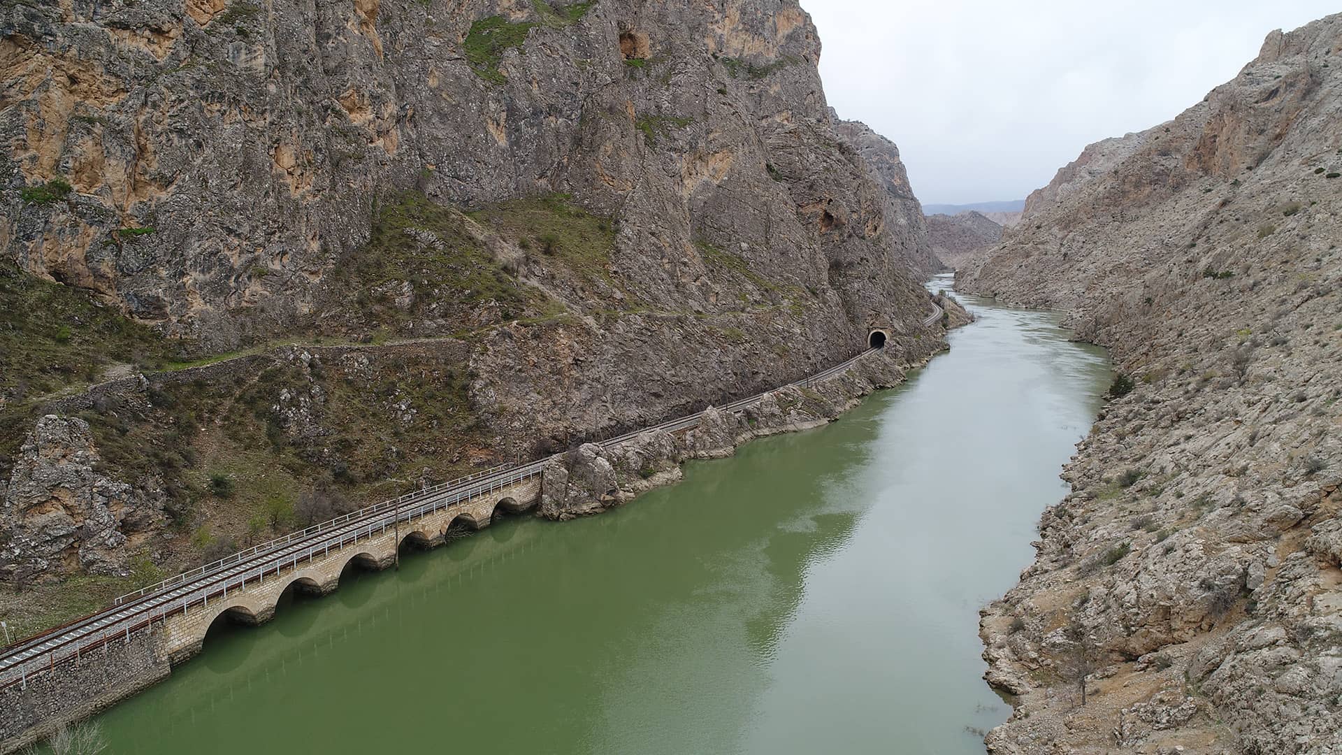
Tucked among the rugged cliffs of the Fırat, Kemaliye is one of Anatolia’s most striking historic towns, with stone houses, wooden balconies, narrow lanes, the Dark Canyon (Karanlık Kanyon), and the famed Taş Yol (Stone Road). Listed on the UNESCO World Heritage Tentative List, Kemaliye offers hiking and boat tours that reveal the might of the river. In 2021, the Historic Town of Kemaliye joined the Cittaslow network. Its houses stand out with authentic vernacular architecture.
Karanlık Kanyon(Dark Canyon)
In Kemaliye, this gorge was carved by the Karasu River, a tributary of the Fırat. Registered in 2020 as a Natural Site–Qualified Natural Protection Area, it stretches about 25 km. With depths over 1,000 m, narrows of 10–15 m, and slopes up to 90%, it is among Türkiye’s most dramatic canyons.
Between two cliff faces at 480 m, special steel lines span 450 m, enabling breathtaking base jump leaps—one of the highest such points in the world. Attracting great interest from visitors, the canyon hosts rafting, mountaineering, cycling, canoe/boat races, microlight, paramotor, paragliding, off-road, and safari events. It is home to otters, lynx, and mountain goats, and each May it hosts the Kemaliye Culture and Nature Sports Festival. Scenic boat tours are another highlight.
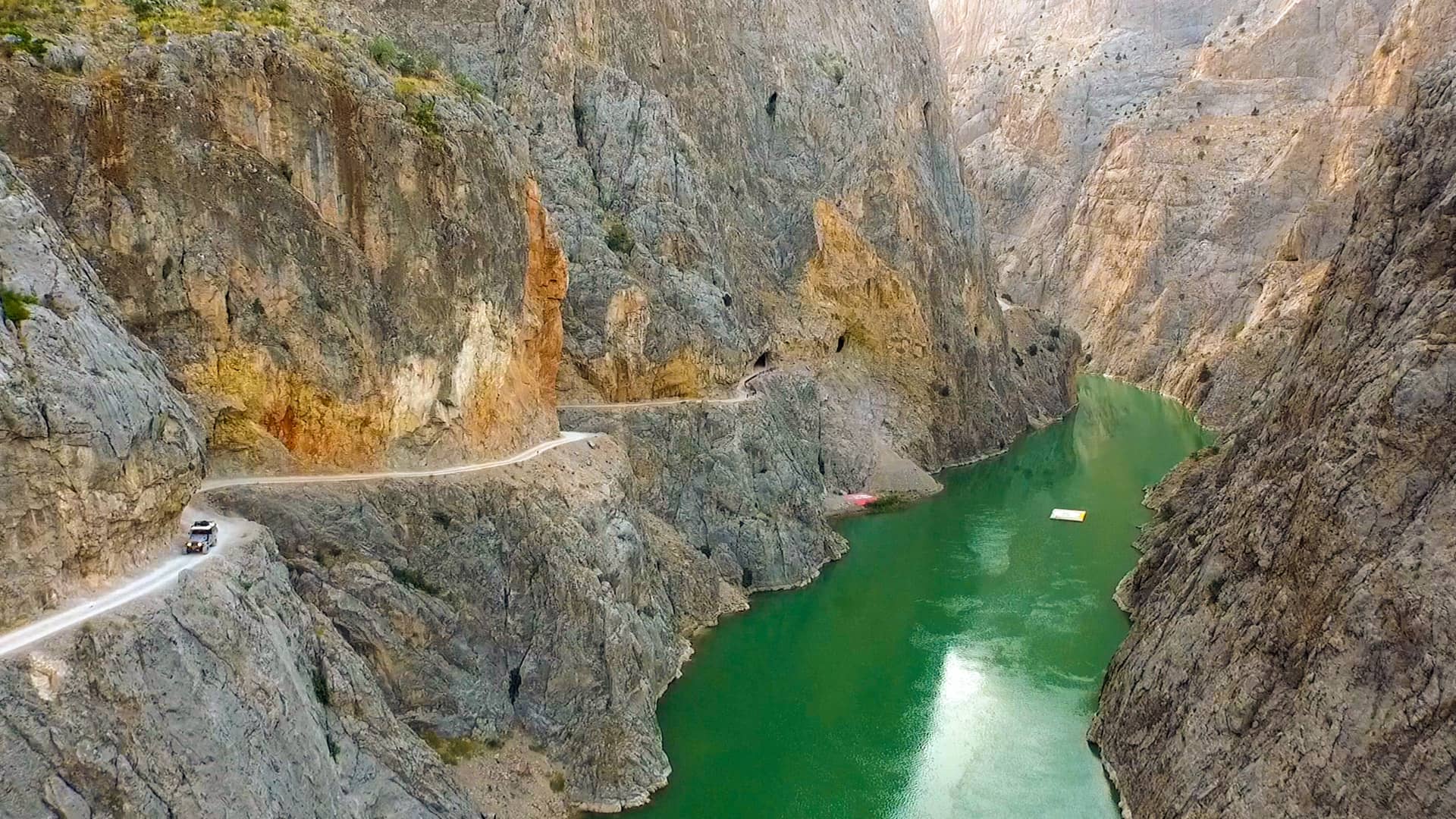
Taş Yol (Stone Road)
This 7 km road, chiseled by locals with primitive tools into the sheer rock of Dark Canyon, is of exceptional natural beauty and aesthetic value. Counted among the world’s most challenging roads, with many tunnels, sharp bends, and precipices, it offers a thrilling journey on foot or by vehicle.
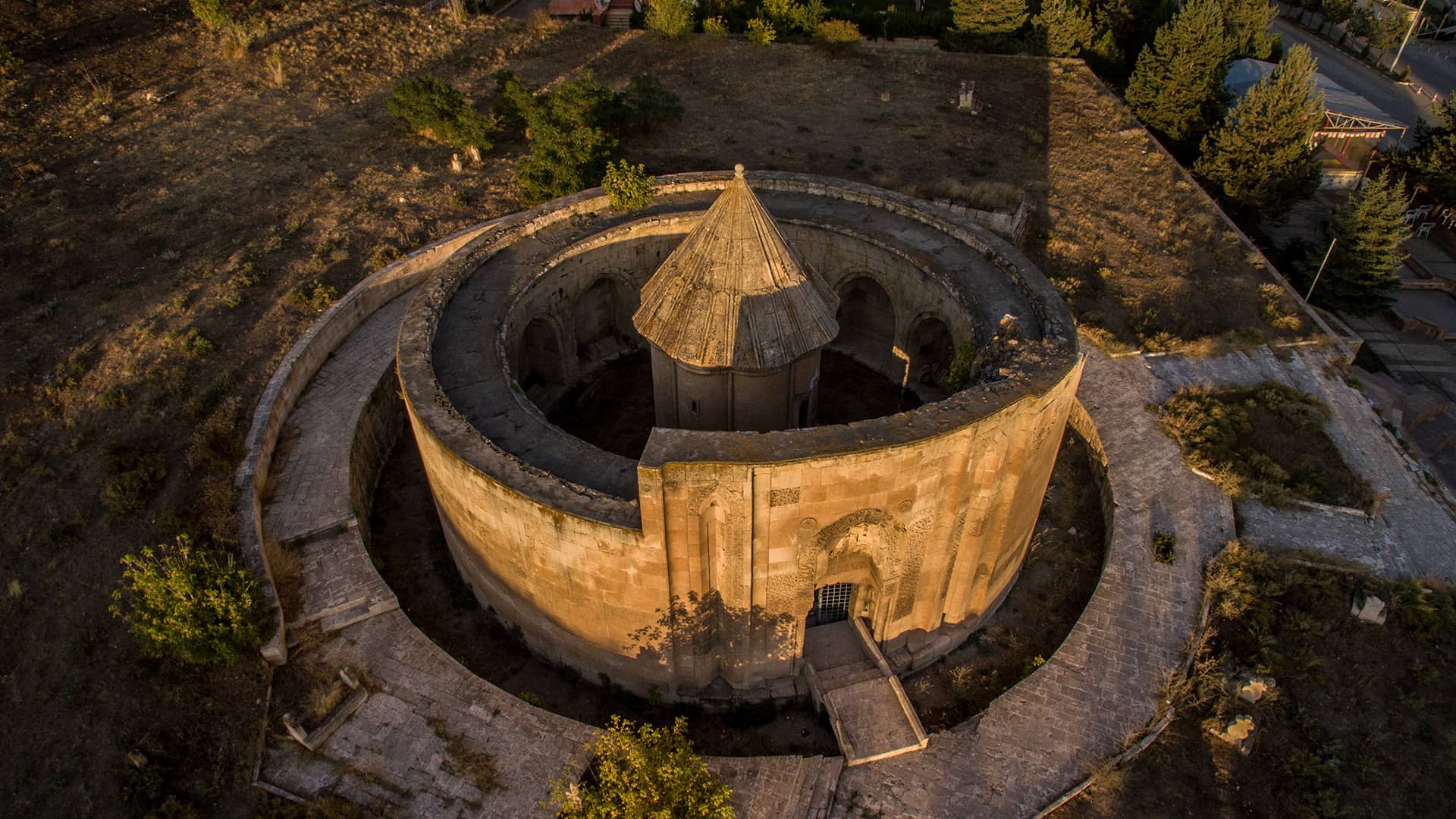
Mama Hatun Caravanserai
Commissioned by Mama Hatun of the Mengücekids, this monumental complex is a symbol of female authority and commerce dating to the 12th century. The Mama Hatun Tomb, with its ribbed body and conical cap encircled by a round wall, presents a unique plan and architectural character unparalleled in Anatolia.
Gastronomy
At harvest time, the aromas of grape must, molasses, and tulum cheese mingle with the flow of the Fırat. Every taste here tells of the land’s labor. Visiting local farms to see tulum cheese production captures how craftsmanship becomes flavor.
TUNCELİ
Where pristine nature meets a unique cultural fabric and traces of the deep past, Tunceli has been a settlement since 5500 BC. Many civilizations of Anatolia left their marks here; natural beauty, culture, and legend draw visitors into a captivating world.
With mountainous terrain, Tunceli holds many rivers and valleys. Although landlocked, the Munzur and Pülümür rivers form popular summer beaches, beloved by locals, that rival the Mediterranean. The province offers rafting, water-skiing, paragliding, trekking, and even a ski facility.
Home to numerous endemic plant species and wild mountain goats, the Munzur Valley National Park enchants with hot springs, untouched landscapes, and distinctive culture, an undiscovered treasure.
Munzur Valley National Park
Stretching between Tunceli and Ovacık, the valley shelters over 1,600 plant species -270 endemic to Tunceli- and rich wildlife including mountain goat, bear, gazelle, wild boar, wolf, and fox. Dominated by oak, the forests also feature elm, maple, alder, ash, plane, birch, walnut, and wild hazelnut.
Summer temperatures approach 30°C; the Munzur River runs with high discharge, ideal for rafting. In 2019, Tunceli hosted the R4 World Rafting Championship, the first international rafting event in Türkiye.
Crown Imperial (Ters Lale)
A bellflower endemic that blossoms naturally in spring and autumn in the Munzur Valley has been registered as Campanula munzurensis. Locally called the “Weeping Bride”, it is under protection.
Ram-Shaped Tombstones
Particularly in Mazgirt, Pertek, and Pülümür, ram-shaped tombstones continue Akkoyunlu Turkmen traditions and depict symbols hinting at the deceased’s identity. Swords, horses, and rams indicate a valorous man; lamps and scales suggest a religious figure; needles, shuttles, or hands may denote a woman. Ewers and trays symbolize generosity, while motifs like Zülfikar (the sword of Ali) and sun discs point to Alevi belief.
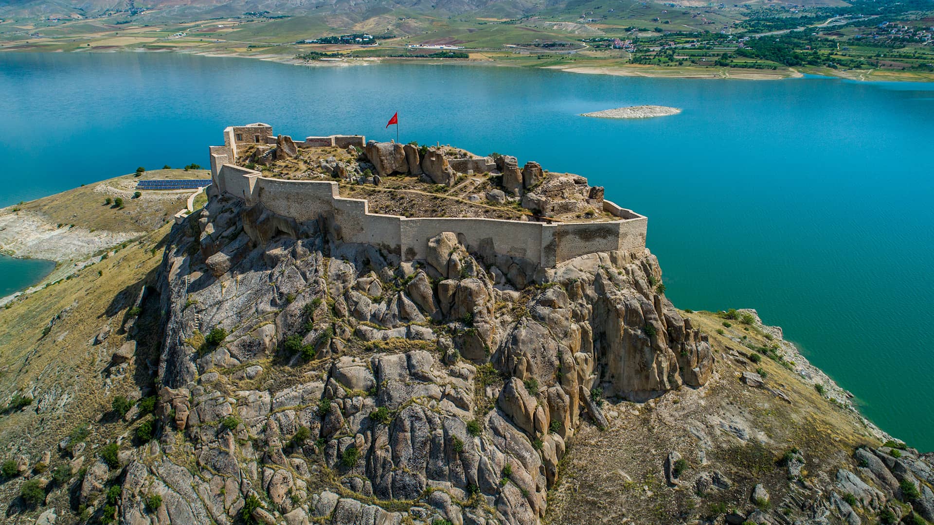
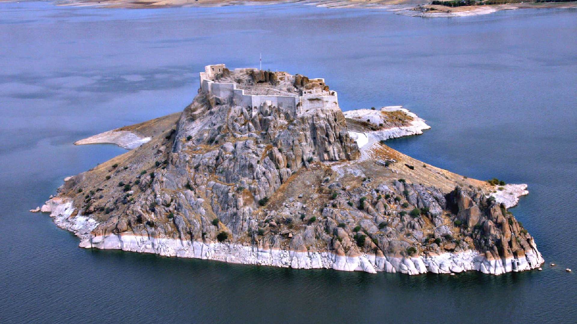
Pertek Castle
After the construction of the Keban Dam, the castle appears as an island. Located 3 km southwest of Pertek, it dates to the 9th century BC and was repaired in the Ottoman era. It can be visited by boat tour.
ELAZIĞ
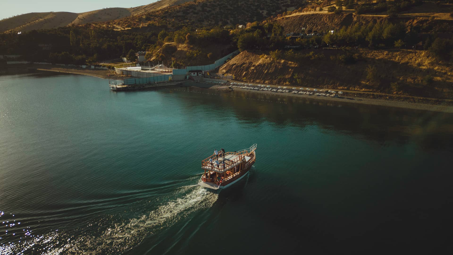
The millennia-old silhouette of Harput Castle meets a landscape dotted with tombs and mosques, framed by Lake Hazar and the horizon of the Keban Dam Lake. One of the Fırat’s most impressive passages, Keban brings boat tours, shoreline walks, and water sports to Elazığ’s crystalline light.
Located on key trade routes, Elazığ has long been a city of faith, culture, and healing, with roots reaching back to the 2nd millennium BC. As the homeland of both the Fırat (Euphrates) and Dicle (Tigris) rivers that nourish Mesopotamia, and as a peninsula of tranquility surrounded by water like Türkiye itself, Elazığ blends fertile lands with Anatolian culture.
The city’s castles, bazaars, mosques, and baths stand as silent witnesses to glorious times. Begin exploring at hilltop Harput, then wander the bazaars, savor local cuisine, and watch the sunset over Lake Hazar. You can also enjoy paragliding, skiing, and hiking at Hazarbaba Mountain.
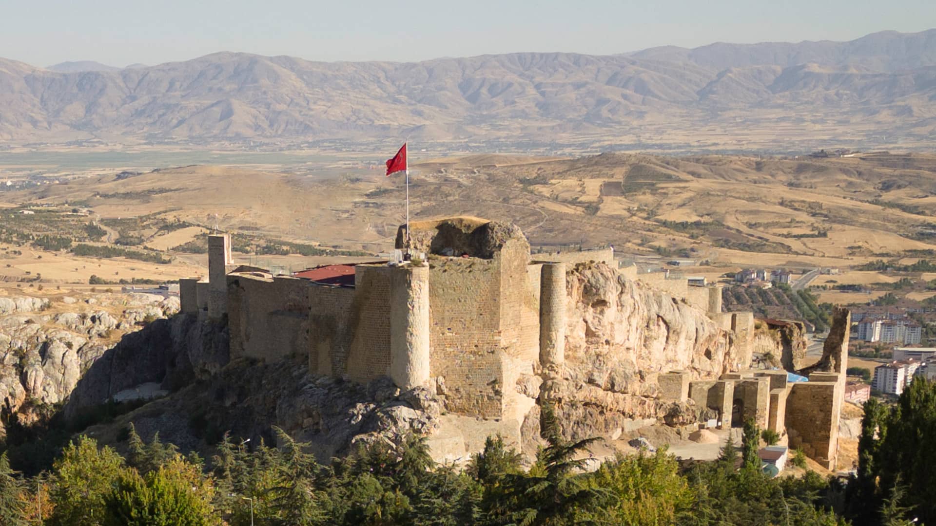
Harput Castle (Süt Kalesi)
Built by the Urartians in the 8th century BC, Harput Castle is Harput’s oldest surviving structure. The nickname “Milk Castle” is tied to a legend that milk was used instead of water in the mortar during a drought when the castle was built. Perched on a steep slope, it affords mesmerizing views.
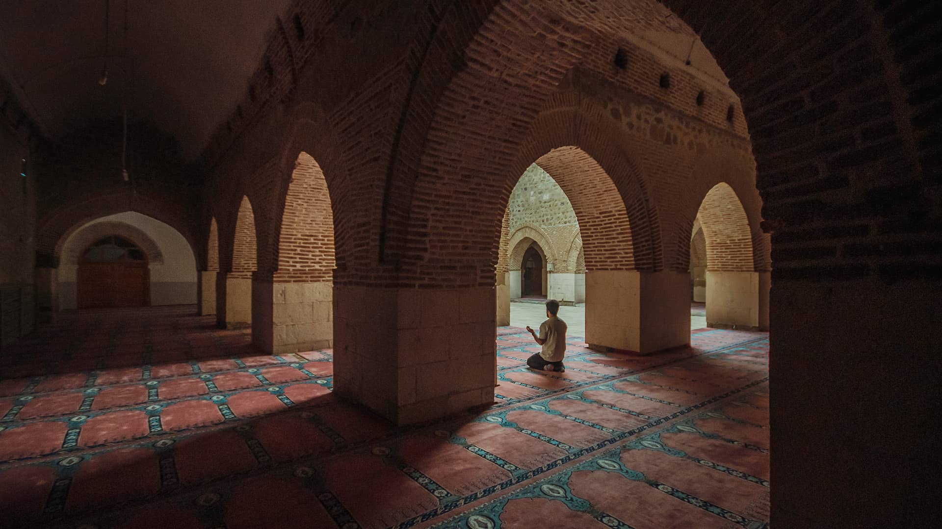
Harput Grand Mosque (Harput Ulucamii)
Also called the “Eğri Minareli Cami” (Inclined Minaret Mosque), it was commissioned in 1157 by Artuqid ruler Fahreddin Karaarslan. Bearing Anatolian and Iranian Seljuk architectural features, it is famed for its leaning minaret and folk tales such as the mulberry tree behind the mihrab bowing as if in prayer.
Keban Dam Lake & Murat River
Crucial to Elazığ’s and Türkiye’s development, the Keban Dam and the Murat River (a major Fırat tributary) make the province a year-round hub for nature and adventure tourism. Hydroelectric production moderated the climate, enriched agriculture, and created new recreation areas and viewpoint restaurants around the lake. Aquaculture and fishing thrive; waymarked hiking routes await visitors. The Murat River invites rafting and other river sports, making Elazığ a four-season destination.
Lake Hazar
A tectonic lake 30 km from Elazığ, Lake Hazar has a 22 km perimeter, an 84 km² surface area, and depths down to 216 m. One of the main sources of the Dicle (Tigris) River, it is among Türkiye’s most scenic lakes. In summer it becomes Elazığ’s holiday center, with hotels, beaches, campsites, recreation areas, and fish restaurants. Boat tours visit islets and the Sunken City. Activities include diving, canoeing, paragliding, parasailing, jet-skiing, water-skiing, pedal boating, and cycling.
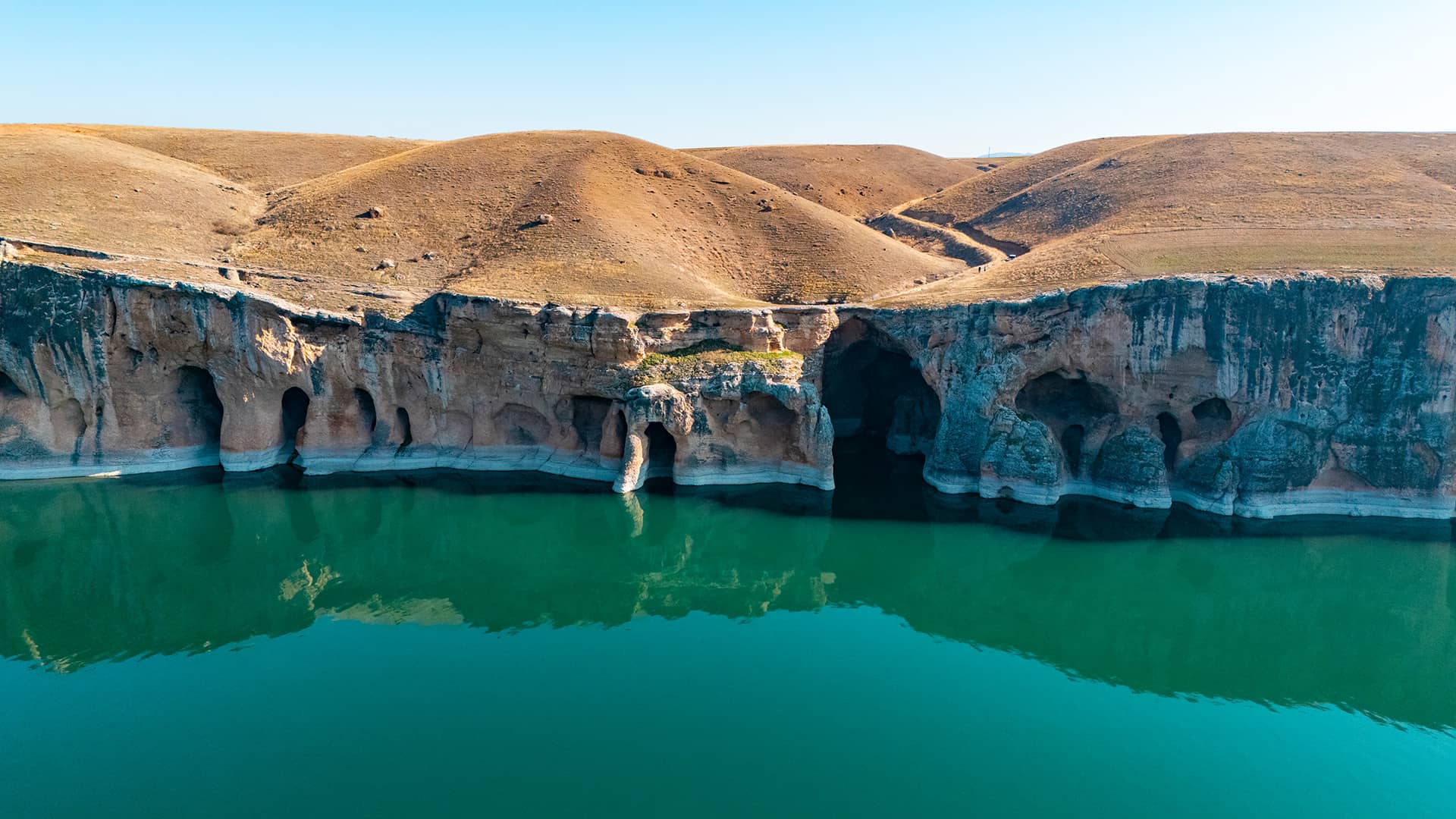
Black Stork Canyon (Kara Leylek Kanyonu)
A natural wonder where an estimated 10–15 thousand pairs of black storks’ nest. Located on the Fırat River within Baskil district, the canyon stretches about 3 km and features many caves, notably Tepesidelik Cave, whose collapsed roof forms a natural bridge. A freshwater spring drips from the ceiling inside. Access is by boat.
Saklıkapı Canyon
In Baskil, this canyon was formed by the Sığdın Stream, a branch of the Fırat. With karstic formations and striking landforms, it fascinates visitors. Among boulders fallen from high slopes, fossils of marine life from millions of years ago have been found.
About 3 km long, its height ranges from 5 to 150 m, and width from 1 to 50 m. Opening to the Fırat, it is an exceptional trekking route for adventure and nature lovers.
MALATYA
As in history, Malatya remains a crucial crossroads bringing civilizations together. Since antiquity it has linked Anatolia and the Middle East. The oldest eastern route runs from Malatya–Sivas to Erzurum and on to the Caucasus; another leads through Malatya and Diyarbakır to Mesopotamia. A southern route through the mountains connects Adıyaman and Urfa to Malatya.
Hittite kings are known to have used these routes in campaigns. King Šuppiluliuma descended along the lower Fırat via this way, likely crossing the river near Malatya. Akkadian King Sargon also campaigned along these paths. Trade and cultural exchange between Mesopotamia and Anatolia along this corridor elevated Malatya’s historical and cultural importance.
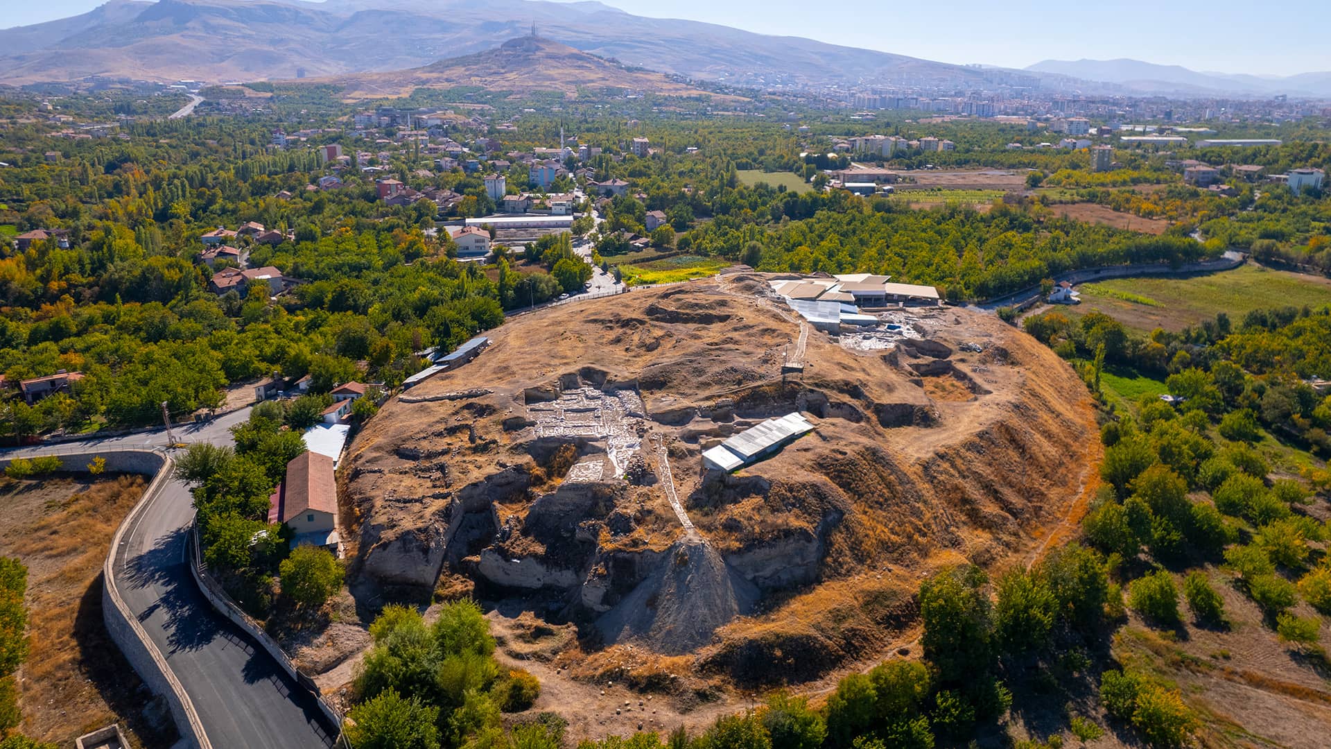
Arslantepe Open-Air Museum
Inscribed on the UNESCO World Heritage List in 2021, Arslantepe Mound lies 6 km from Malatya city center. Inhabited from c. 5000 BC to the 11th century AD, it served as a Roman village in the 5th–6th centuries AD and later as a necropolis. Opened as an open-air museum in 2011, excavations revealed the world’s oldest known mudbrick palace (3300–3000 BC), a temple (3600–3500 BC), over 2,000 sealings, corridor decorations, a royal tomb, and the world’s earliest known 9 swords and 12 spearheads, among many finds. Replicas of King Tarhunza of Malatya, two lion statues, and reliefs (originals discovered 1900-1932 and taken to Ankara) welcome visitors. Items not displayed on site are exhibited at the Malatya Museum.
Battalgazi Grand Mosque
Built between 1211–1220 during İzzeddin Keykavus’s reign, this mosque exemplifies the open-courtyard, iwan-plan developed in Great Seljuk Iran, featuring a domed bay before the mihrab and extensive use of glazed brick and tile. It originally had a stucco mihrab and a significant kündekâri (interlocking wood) minbar. It is a key monument of Anatolian Seljuk architecture and ornament.
Levent Valley
About 47 km from Malatya, in Akçadağ, these 28 km-long geological marvel dates back 65 million years, shaped by tectonic deformation. With extraordinary formations, cliffs, and hundreds of caves with rock reliefs, it is one of the world’s most intriguing natural areas. The 104 m-high Viewing Terrace plays a major role in introducing Levent Valley, a foremost geo-archaeology center in Anatolia. Hiking, rock climbing, camping, scouting, and alternative outdoor activities are possible.
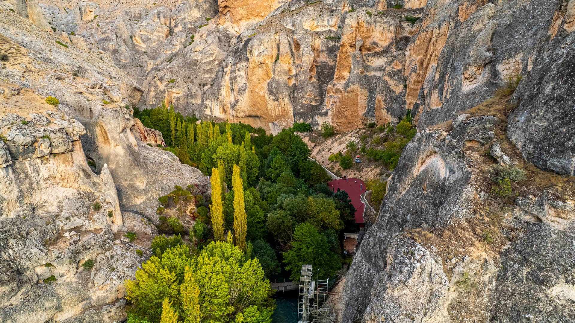
Tohma Canyon
In Darende, Tohma Canyon is a favorite of nature lovers. Shaped over millennia by the Tohma Stream, it boasts lush vegetation, crystal-clear waters, and soothing vistas. Steep rocky slopes and cave-like hollows draw attention. A canal carved into the rock once carried water to the Somuncu Baba Mosque. Activities include trekking, rafting, photo safaris, and climbing.
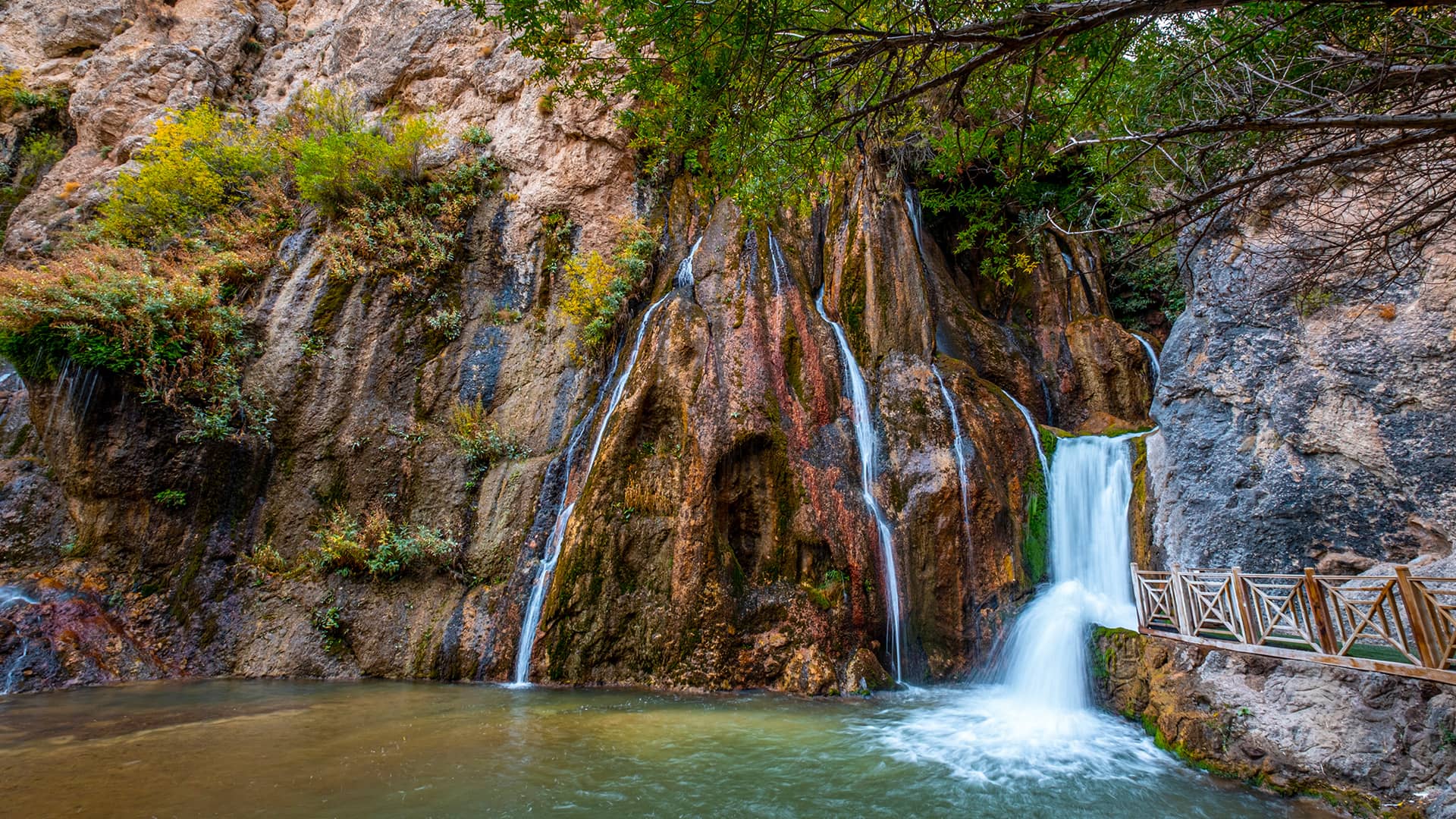
Günpınar Waterfall Nature Park
Located 114 km from Malatya center and 8 km from Darende, the waterfall cascades in three tiers from about 40 m. Declared a Nature Park in 2018, it offers picnic areas, walking paths, and rustic eateries. The 2 km Günpınar Valley between the springs and the falls is ideal for trekking.
Radio and Gramophone Museum
Founded by the Metropolitan Municipality in 2018, Türkiye’s largest Radio and Gramophone Museum displays 703 items. Sections include Malatya Radio, Fahri Kayahan, Political History, First Radio Broadcast, and a Radio Repair Shop.
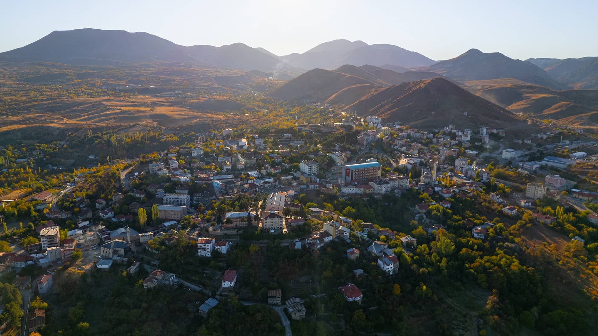
Arapgir
Set on the fertile lands of the Fırat River Basin, Arapgir carries the traces of ancient civilizations with a history reaching back to 1200 BC. Once an important stop along the Historic Silk Road, the town today proudly bears the title of Cittaslow, where the tranquility of the past meets the calm rhythm of modern life.
As you wander its stone-paved streets, the elegant Ulu Mosque and Gümrükçü Osman Pasha Mosque greet you with the refined grace of Ottoman architecture. With its bridges, historic mansions, and traditional Arapgir Houses, the town feels like an open-air museum — every corner a picture waiting to be captured.
In the Kozluk Stream Canyon, you can take peaceful walks surrounded by nature, and savor local delicacies made with the world’s only Köhnü grape and the fragrant Arapgir Purple Basil — symbols of the town’s rich agricultural heritage.
ADIYAMAN
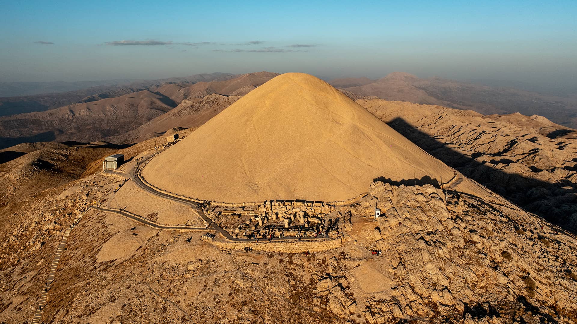
A land that has embraced many civilizations, Adıyaman whispers much from the past. Bridging Anatolia and Mesopotamia, it carries the southern spirit of the Fırat. Here, history, belief, and nature gather in a single panorama. To feel the allure of Mount Nemrut—whose colossal statues of gods and kings have fascinated the world for centuries and which, with its historical richness and natural beauty, is inscribed on the UNESCO World Heritage List—watch sunrise or sunset from its summit. Every beam of light revives stories thousands of years old.
Nemrut Archaeological Site (Nemrut Örenyeri)
Within Kahta district, the monumental tumulus and statues erected by King Antiochos I of Commagene at 2,206 m on Mount Nemrut are among the most spectacular remains of the Hellenistic Period. The colossal statues, made of limestone and sandstone blocks, are arranged on east, west, and north terraces.
Although the tumulus originally rose 55 m, centuries of natural and human impact reduced it to about 50 m. Composed of 30,000 m³ of crushed stone, it is known to be the funerary monument of King Antiochos I.
Mount Nemrut Terraces
To watch the sun rise and set “from the same throne as the gods,” Antiochos I had statues built of Kommagene (Tyche), Zeus–Oromasdes, Apollon–Mithras, and Herakles–Artagnes, seated in a row on thrones about 10 m high, accompanied by a guardian eagle (celestial dominion) and a guardian lion (earthly rule) as symbols of the Commagene Kingdom.
Behind the thrones stands a 234-line inscription of the king’s religious and social testament. To the north and south are relief stelae of Persian kings of Commagene. On the east terrace, in front of the statues, there is a fire altar and a seated lion. Sunrise is watched from this terrace. On the west terrace, the famous lion horoscope relief shows the date of 7 July 62 BC inferred from the moon and stars regarded as the world’s oldest astronomical calendar depiction and indicating Antiochos’s accession.
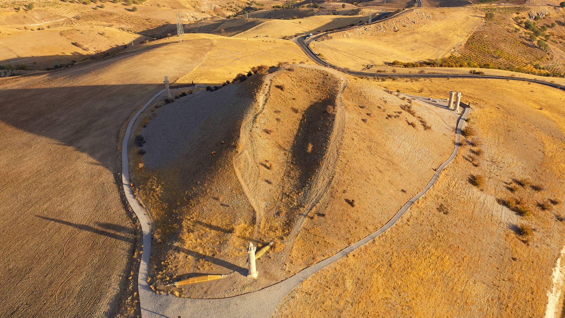
Karakuş Tumulus
Built on a commanding point and visible from all sides, the tumulus measures 110 m in diameter and 21 m in height, covered with stones brought from the Kahta stream. Conical in form, it resembles an artificial hill; today, parts are covered by earth and others by cut stone.
It takes its name from the magnificent 2.54 m eagle statue on a southern column—Zeus’s herald and the Commagene symbol of celestial sovereignty. The tumulus was erected by King Mithridates II (36–21 BC) in honor of his mother Isias; her daughters Laodice and Antiochis, and Aka (Antiochis’s daughter) are interred here.
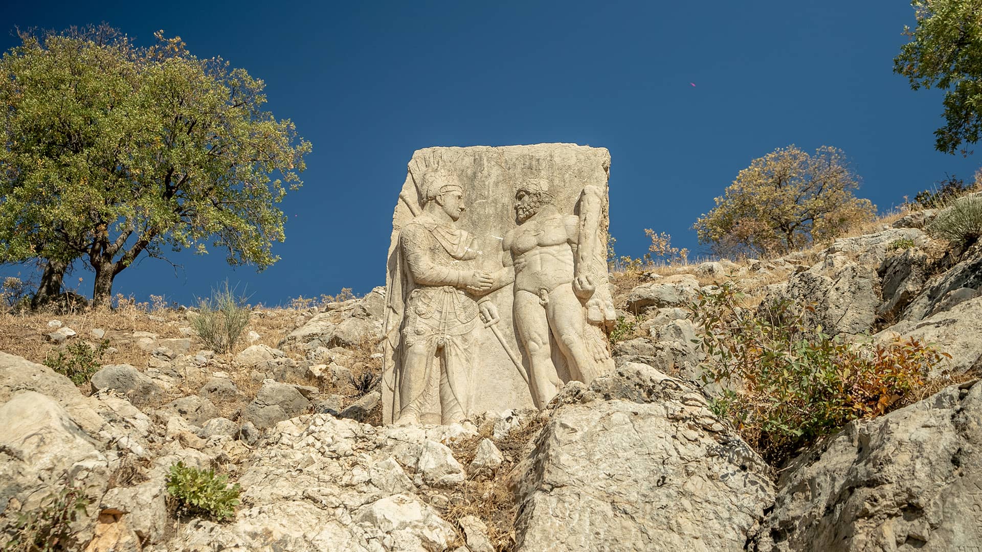
Arsameia Archaeological Site
Discovered in 1951 by F. Karl Dörner, Arsameia’s history became clear after the central inscription was deciphered. It states that Arsemes, an ancestor of Antiochos I on his father’s side who lived in the early 3rd century BC, founded the city. Most remains visible today were built by Antiochos I, who designated the site as a “Hierothesion” (Sacred Area)—a Greek term unique to Commagene denoting a royal sacred tomb.
Perched on sheer rocks, the site is reached via a ceremonial path lined with relief stelae, a rock-cut monumental tomb chamber, Anatolia’s largest Greek inscription, a tunnel, and architectural remains at the summit. The central inscription spans five columns with 256 lines, and beneath it descends a 158 m sacred passage. Nearby stands the celebrated dexiosis relief of Antiochos I, shaking hands with Herakles. Along the “Sacred Road,” intermittent dexiosis stelae likely prepared participants for the ritual atmosphere; Antiochos portrays himself on par with the gods, a god-king.
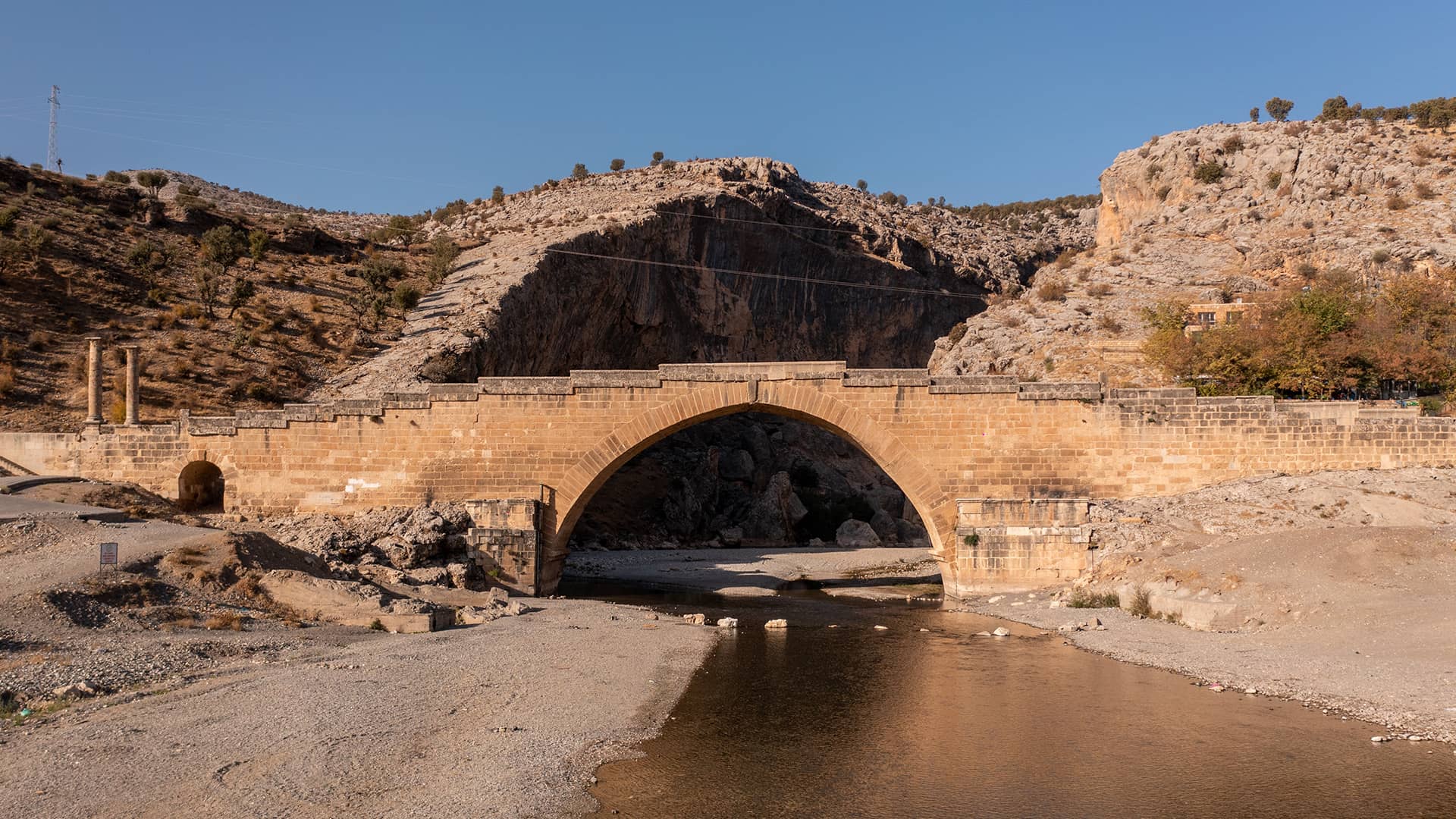
Cendere Bridge
Spanning the Cendere Stream, the bridge was built between AD 198–200 during the reign of Emperor Septimius Severus by the 16th Roman Legion stationed in Samosata under Marius Perpetuus, commanded by Alfenius Senecio.
Measuring 120 m long and 7 m wide with a 32.20 m main arch span, the bridge rises toward the center with ramped approaches. A small drainage arch sits beneath the south ramp. Today three columns stand at the entrances; originally there were four—two Corinthian columns at the south entrance dedicated to Septimius Severus and Julia Domna, and two at the north dedicated to their sons Caracalla and Geta. After seizing power, Caracalla had Geta killed in AD 212 and erased his memory across the empire, removing the fourth column.
An inscription on a southern column mentions “Quattuor Civitates Commagenorum”—Samosata, Doliche, Perre, and Germanikeia—the four Commagene cities that financed the bridge. Standing for 1,800 years, the bridge was closed to vehicles after restoration in 1997 and remains one of Türkiye’s best-preserved Roman bridges.
Gerger Canyon (Takoran Valley)
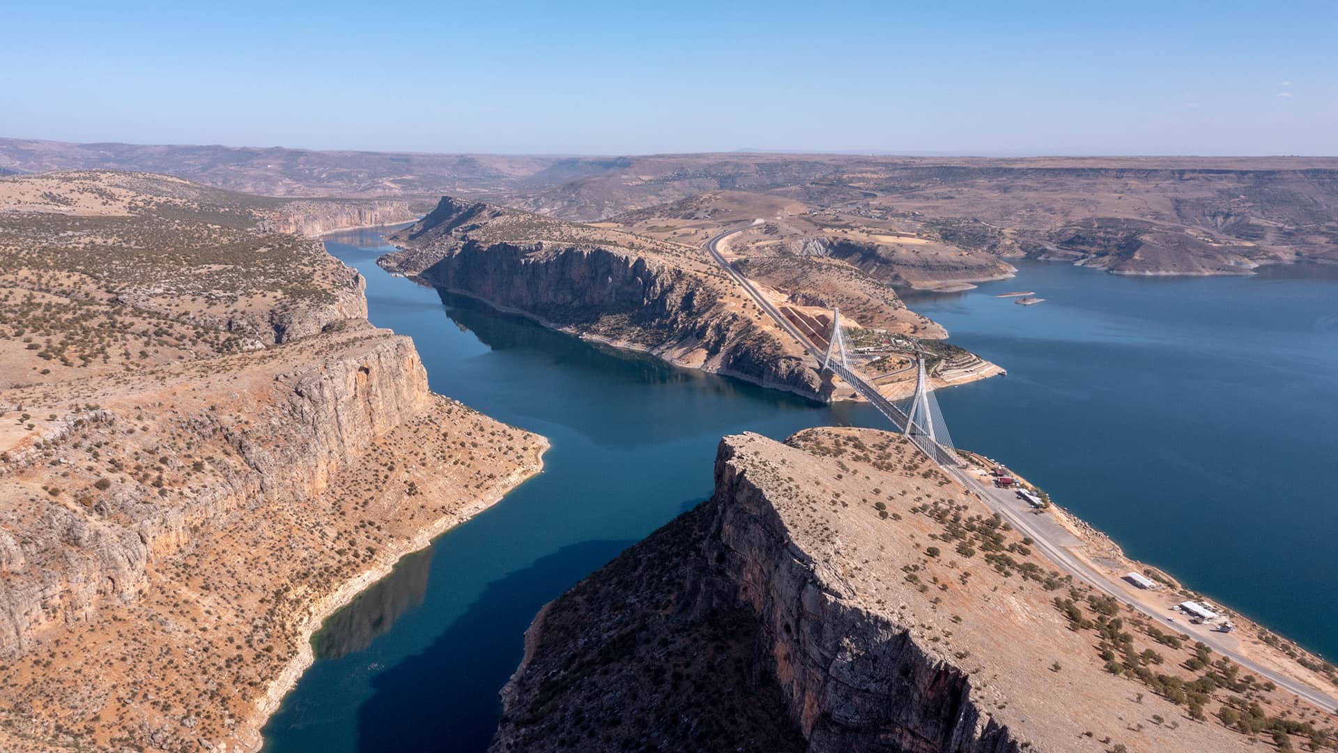
Within Gerger district at the confluence of the Fırat River and Atatürk Dam Lake, this striking natural wonder is framed by sheer cliffs, deep valleys, and enchanting vistas. Boat tours reveal the scenery from the water; hiking trails invite nature walks and exceptional photography. The area also features ancient caves, rock tombs, and remnants of earlier civilizations. Known as “Takoran Valley,” Gerger Canyon captivates both nature lovers and history enthusiasts.